LiberiaDownload light PDF version
Overview
Founded by freed American slaves in 1847 with the encouragement of US President Monroe (for whom the capital city was given its name), Liberia emerged in 2003 from a longstanding civil war that had seriously affected the region. The country held free and fair elections in 2005 with the support of the UN Mission in Liberia (UNMIL), the largest peacekeeping operation in the world at that point.
With Ellen Johnson Sirleaf, the first female president in Africa and the 2011Nobel Peace Prize laureate, at its head, Liberia is recovering from the lingering effects of the civil war and the related economic dislocation. The 2011 elections were a crucial test of Liberia’s transition to full constitutional rule and participatory democracy.
Richly endowed with natural resources, Liberia is a producer and exporter of raw products, primarily timber and rubber and has the highest Foreign Direct Investment to GDP ratio in West Africa.
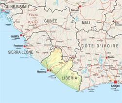
Liberia founded the Mano River Union together with Guinea and Sierra Leone. Transport infrastructure in the country remains, however, seriously underdeveloped, which impedes trade with its three neighbours.
Institutional Framework
| Government type: | Republic |
| Constitution: | 6 January 1986 |
| Legal system: | mixed legal system of common law (based on Anglo-American law) and customary law |
| Administrative division | 15 counties: Bomi, Bong, Gbarpolu, Grand Bassa, Grand Cape Mount, Grand Gedeh, Grand Kru, Lofa, Margibi, Maryland, Montserrado, Nimba, River Cess, River Gee, Sinoe |
| Executive branch: |
|
| Legislative branch: | bicameral National Assembly consists of the Senate (30 seats; members elected by popular vote to serve nine-year terms) and the House of Representatives (73 seats; members elected by popular vote to serve six-year terms) |
| Judical branch: | Supreme Court |
| Political parties: |
|
| Suffrage: | 18 years of age; universal |
| Elections: | President elected by popular vote for a six-year term (eligible for a second term); elections last held on 11 October and 8 November 2011 (next to be held in 2017) |
| Election results: | Ellen JOHNSON SIRLEAF re-elected president; percent of vote, second round - Ellen JOHNSON SIRLEAF 90.7%, Winston TUBMAN 9.3% |
| Central bank: | Central Bank of Liberia |
| Military branches: | Armed Forces of Liberia (AFL): Army, Navy, Air Force |
| Military age and obligations: | 18 years of age for voluntary military service; no conscription (2010) |
| Membership in regional organisations: | AfDB, AU, ECOWAS, Cen-sad, MRU |
Regional Indicators
- Land boundaries: 1585 km
- Border countries: Guinea 563 km, Cote d'Ivoire 716 km, Sierra Leone 306 km
- Coastline: 579 km
- Airports: 29 with paved runways: 2 (2010)
- Railways: 429 km
- Roadways: 10 600 km; paved: 657 km; unpaved: 9 943 km (2006
- Waterways: ------
- Ports and terminals: Buchanan, Monrovia
Demographic Trends
- Population 2010: 3 994 000
- Projection 2050: 9 660 000
- Population < 15 years: 1 737 390 (43.5% * 3 994 000= 1 737 390)
- Population density: 36
- Urban agglomeration: Monrovia (827 000 =20.2%)
- Annual Growth: 4.54% (2005-2010) > 2.64% (2010-2015)
- Woman fertility (children per women): 5.42 (2005-2010) > 5.04 (2010-2015)
- Median age: 18.2
- Dependency ratio: 86
Migration and Mobility
- Number of emigrants (2010): 431 900 =10.5% of pop
- Number of immigrants (2010): 96 300 = 2.3% of pop
- Top destination countries: Guinea, Côte d’Ivoire, the United States, Sierra Leone, Nigeria, Germany, Italy, Australia, the Netherlands, the United Kingdom
- Refugees within country: 10 200 (2009)
Economic Indicators
- GDP total: USD 2 266 million
- GDP per capita: USD 552
- Annual Growth: 4.6%
- Average growth (2002-2010): 1.7%
- Currency: Liberian dollars (LRD)
- Inflation Rate: 7.6%
- Main Exports: rubber, timber, iron, diamonds, cocoa, coffee
- Main Export partners: Germany 29.3%, Poland 18%, South Africa 16.6%, Greece 7.4%, US 6.5%, Norway 5.5% (2009)
- Main Imports: fuels, chemicals, machinery, transportation equipment, manufactured goods; foodstuffs
- Main import partners: South Korea 41.7%, China 16%, Singapore 14.1%, Japan 12.6% (2009)
- Trade balance: USD -410 million
- Net Foreign Direct Investment inflows: USD 378 million
- Estimated Diaspora Remittances 2009: 6.2% of GDP
- = USD 54 million
- = USD 13.52 per capita
- ODA received: USD 505 million
- =as % of GDP: 22.28%
- =per capita: USD 126.43
- Category: Low income (2011)
- Public Spending on:
- Education as a percentage of total government expenditure (2000-2007): N.A
- Health as a percentage of total government expenditure (WHO, 2009): 16.4%
- Military: USD 7.2 million =0.8% of GDP (2009)
- External Debt: USD 1660 million
- Debt service (as % of Exports 2010e): 126%
- Public finance (% of GDP 2009):
- Revenue and grants: 27.4%
- Expenditures and net lending: 29%
- Overall balance: -1.6
- IMF Adjustment Programme: yes
- Corruption Perception Index (xx/10): 3.3 (87/178)
- Index of Economic Freedom (xx/100): 46.5 (160/179)
- WB Doing Business index 2011: 155/183
- Ibrahim African Governance index: 48.7
Food Security
| Global Hunger Index (IFPRI, 2011): | 21.5 |
| Food supply (kcal per capita/day) | 2 163 |
| Number of people undernourished: | 1.2 million |
:Percentage of people undernourished: | 33% |
| Child malnutrition, underweight: | 26% |
| Child malnutrition, stunting: | 39% |
Land use
| Land area (1 000 ha): | 9 632 |
| Agricultural land area (1 000 ha): | 2 610 |
Arable land (1 000 ha): | 400 |
| Permanent crops (1 000 ha): | 218 |
| Pastures (1 000 ha): | 2 000 |
| Irrigated land (1 000 ha): | 3 |
| Share in total water use by |
|
| Forest area (1000 ha): | 4 329 |
Source: FAOStat and FAO Country Profile
Social Indicators
Religion & Ethnicity
- Ethnic Groups : Kpelle 20.3%, Bassa 13.4%, Grebo 10%, Gio 8%, Mano 7.9%, Kru 6%, Lorma 5.1%, Kissi 4.8%, Gola 4.4%, other 20.1% (2008 census)
- Major Religions: Christian 85.6%, Muslim 12.2%, traditional 0.6%, other 0.2%, none 1.4% (2008 census)=
Health
- Life Expectancy: 58.1 (2005-2010)
- Under-five Mortality Rate (per 1000 live births) (2008): 145
- Number of physicians (for 100 000 people) (2004): 3.1
- Hospital Beds (for 10 000 people): N.A
- Estimated HIV prevalence (2007): 1.7%
Education:
- Adult literacy rate: (% age 15 and above): 58,1% (2008)
- Youth Literacy Rate: 74,8% (2008)
- Net Primary Enrolment Ratio: 539887 (2008)
- Net Secondary Enrolment Ration: 158242 (2008)
- Tertiary Students: N.A
- University attendance Ration: N.A
ICT & Media:
- Internet Access (per 100 inhabitants) 2009: 0.51
- Internet domain: .lr
- International dialing code: 231
- Mobile line (per 100 inhabitants) 2009: 21.29
- Main telephone line (per 100 inhabitants) 2009: 0.05
Basic Services
- Access to electricity 2007: kWh 333 millions
- Water supply coverage 2008: 68% (urban 79%, rural 51%)
- Sanitation coverage2008: 17% (urban 25%, rural 4%)