MaliDownload light PDF version
Overview
Mali is currently recovering from its worst political and humanitarian crisis since independence. The election of President Ibrahim Boubacar Keïta on 11 August 2013 ended 18 months of constitutional disorder precipitated by a military coup in March 2012. Military officers, dissatisfied with President Amadou Toumani Touré’s handling of a Tuareg rebellion in the north, deposed ATT just weeks before scheduled presidential elections, bringing an end to 20 years of uninterrupted democratic rule. The political crisis emboldened the rebels, who soon after declared an independent state in northern Mali. Fully two-thirds of the country’s territory was occupied by Tuareg militants and the Islamist groups who quickly overran the insurgency, instituting a harsh form of Sharia law. More than 350 000 people fled south or to neighbouring countries, and the humanitarian situation deteriorated.
Following the official resignation of President Touré on 8 April, a transitional government was formed and tasked with restoring Mali’s territorial integrity and organising presidential elections. ECOWAS spearheaded the formation of the African-led International Support Mission to Mali (AFISMA) to help the Malian army regain control of the country’s three northern regions. With Islamists threatening to push south toward Bamako, France launched a military intervention in January 2013. With the support of Malian, Chadian and other AFISMA troops, the French offensive succeeded in dislodging the Islamists from all the main cities. This, and the signing of a provisional peace accord between the transitional government and Tuareg rebels who continued to control Kidal, cleared the way for presidential elections to be held throughout the country. On 1 July 2013, AFISMA authorities handed over to an international peacekeeping mission, the United Nations Multidimensional Integrated Stabilization Mission in Mali (MINUSMA).
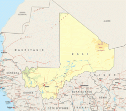
Mali, which is most well known for its vast desertic area (two-thirds of the country is covered by desert), has by far the longest total border lines in West Africa (7 200 km, compared to 5 700 for Niger and 4 000 for Nigeria). Managing these extensive borders is a constant challenge that is further complicated by recurring Tuareg irredentism and the presence of AQIM in Northern Mali.
Mali has considerable agricultural potential, which could meet the needs of the regional market. Mali alone accounts for 20% of currently irrigated land in West Africa and could feasibly double that total. It shares the largest cotton basin in Africa with Burkina Faso and Côte d’Ivoire, and international investors have become increasingly interested in its water and land resources, in particular for biofuel production.
The country also has significant mining resources that have not yet been extensively explored. While gold is Mali’s most important source of revenue before cotton. Its iron, bauxite and magnesium resources remain unexploited. Important exploratory operations at oil and gas sites are, however, underway.
Landlocked and highly dependent upon good relations with its neighbours, Mali has been a pioneer country for West African regional integration. Malian President Alpha Oumar Konaré launched the “cross-borders” concept in 2000, and the idea was realised a decade later through the ECOWAS Cross-border Initiatives Programme. UEMOA has also made cross-border co-operation one of its top priorities.
Interactive map: understanding the situation in Mali... by lemondefr
Institutional Framework
| Government type: | Republic |
| Constitution: | adopted 12 January 1992 |
| Legal system: | civil law system based on the French civil law model and influenced by customary law; judicial review of legislative acts in Constitutional Court |
| Administrative division | 8 regions: Gao, Kayes, Kidal, Koulikoro, Mopti, Segou, Sikasso, Tombouctou |
| Executive branch: |
|
| Legislative branch: | |
| Judical branch: | Supreme Court |
| Political parties: |
|
| Suffrage: | 18 years of age; universal |
| Elections: | President elected by popular vote for a five-year term (eligible for a second term); election last held on 29 April 2007 (next to be held on 29April 2012); prime minister appointed by the president |
| Election results: | Ibrahim Boubacar KEITA elected president in a runoff election; percent of vote Ibrahim Boubacar KEITA 77.6%, Soumaila CISSE 22.4% |
| Central bank: | Central Bank of West African States (BCEAO) |
| Military branches: | Malian Armed Forces: Army, Republic of Mali Air Force (Force Aérienne de la République du Mali, FARM), National Guard (2008) |
| Military age and obligations: | 18 years of age for compulsory and voluntary military service; conscript service obligation - 2 years (2010) |
| Membership in regional organisations: | AfDB, AU, ECOWAS, UEMOA, CILSS, OMVS, ABN, ABV, Cen-sad |
Source: CIA Factbook, Country Profile
Regional Indicators
- Land boundaries: 7243 km
- Border countries: Algeria 1,376 km, Burkina Faso 1,000 km, Guinea 858 km, Cote d'Ivoire 532 km, Mauritania 2,237 km, Niger 821 km, Senegal 419 km
- Coastline: 0 km
- Airports: 20 with paved runways: 8 (2010)
- Railways: 593 km
- Roadways: 18 709 km; paved: 3 368 km; unpaved: 15 341 km (2004)
- Waterways: 1,800 km (downstream of Koulikoro; low water levels on the River Niger cause problems in dry years; in the months before the rainy season the river is not navigable by commercial vessels) (2010)
- Ports and terminals: Koulikoro
Demographic Trends
- Population 2012: 15 900 000
- Projection 2050: 42 130 000
- Population < 15 years: 7 600 000 (47.7% *15 900 000 =7 600 000)
- Population density: 12/ sq.km
- Urban agglomeration: Bamako (1 699 000 =12.7%)
- Annual Growth: 3.08% (2005-2010)> 2.96% (2010-2015)
- Woman fertility (children per women): 6.46 (2005-2010)> 6.12 (2010-2015)
- Median age: 16.3
- Dependency ratio: 97
Migration and Mobility
- Number of emigrants (2010): 1 012 700 =7.6% of pop
- Number of immigrants (2010): 162 700 = 1.2% of pop
- Top destination countries: Côte d’Ivoire, Nigeria, Niger, France, Burkina Faso, Gabon, Spain, Senegal, Guinea, The Gambia
- Refugees within country: 12 400 (Mauritania) (2012)
- Internally displaced persons: 228 918 (2013)
Economic Indicators
- GDP total: USD 18 280 million
- GDP per capita: USD 1 100
- Real GDP Growth: 6.7% (2014 forecast)
- Average Growth (2002-2010): 4.9%
- Currency: CFA Franc
- Inflation Rate: 5.4% (2012)
- Inflation Rate: 2.9% (2011)
- Main Exports: cotton, gold, livestock
- Main export partners: China 53.7%, Malaysia 11.2%, Indonesia 5.4%, India 4.1% (2012)
- Main Imports: petroleum, machinery and equipment, construction materials, foodstuffs, textiles
- Main import partners: France 10.9%, Senegal 9.7%, China 8.4%, Cote dIvoire 8% (2012)
- Trade balance: USD -134 million
- Net Foreign Direct Investment inflows: USD 109 million
- Estimated Diaspora Remittances 2009: 4.8% of GDP
- = USD 405 million
- = USD 26.35 per capita
- ODA received: USD 985 million
- =as % of GDP: 6.46%
- =per capita: USD 64.08
- WB Category: Low income (2011)
- Public Spending on:
- Education as a percentage of total government expenditure (2012): 20.0%
- Health as a percentage of total government expenditure (2012): 8%
- Military: USD 174 million =1.9% of GDP (2009 e)
- External Debt: USD 2 620 million (2012)
- Debt service (as % of Exports 2012e): 3.3%
Public finance (% of GDP 2011, 2012):
- Revenue and grants: 20.6 , 16.3
- Expenditures and net lending: 23.9 , 22.6
- Overall balance: -3.3 , -6.4
- IMF Adjustment Programme: yes
- Corruption Perception Index (xx/10): 2.7 (116/178)
- Index of Economic Freedom (xx/100): 56.3 (114/179)
- WB Doing Business index: 155/189 (2013)
- Ibrahim African Governance index: 50.7 (2013)
Food Security
| Global Hunger Index (IFPRI, 2013): | 14.8 |
| Food supply (kcal per capita/day) | 2 571 |
| Number of people undernourished: | 1.5 million |
:Percentage of people undernourished: | 12% |
| Child malnutrition, underweight: | 33% |
| Child malnutrition, stunting: | 38% |
Land use
| Land area (1 000 ha): | 122 019 |
| Agricultural land area (1 000 ha): | 41 621 |
Arable land (1 000 ha): | 4 815 |
| Permanent crops (1 000 ha): | 130 |
| Pastures (1 000 ha): | 34 650 |
| Irrigated land (1 000 ha): | 236 |
| Share in total water use by |
|
| Forest area (1000 ha): | 12 490 |
Source: FAOStat and FAO Country Profile
Social Indicators
Religion & Ethnicity
- Ethnic Groups : Mande 50% (Bambara, Malinke, Soninke), Peul 17%, Voltaic 12%, Songhai 6%, Tuareg and Moor 10%, other 5%
- Major Religions: Muslim 90%, Christian 1%, indigenous beliefs 9%
Health
- Life Expectancy: 54.55 (2013
- Under-five Mortality Rate (per 1000 live births) (2013): 106.49
- Number of physicians (for 100 000 people) (2011): 8.3
- Hospital Beds (for 10 000 people): 1 (2010)
- Estimated HIV prevalence (2009): 1%
Education:
- Adult literacy rate: (% age 15 and above): 33.4% (2011)
- Youth Literacy Rate: 38.8% (2006)
- Net Primary Enrolment Ratio: 1926242 (2009)
- Net Secondary Enrolment Ration: 686071 (2009)
- Tertiary Students: N.A
- University attendance Ration: 5.5% (2009)
ICT & Media:
- Internet Access (per 100 inhabitants): 1.92
- Internet domain: .ml
- International dialing code: 223
- Mobile line (per 100 inhabitants) 2009: 34.17
- Main telephone line (per 100 inhabitants) 2009: 0.65
Basic Services:
- Access to electricity 2007: kWh 487 millions
- Water supply coverage 2008: 56% (urban 81%, rural 44%)
- Sanitation coverage2008: 36% (urban 45%, rural 32%)